The L2B sea surface wind field product version 1.0 of microwave scatterometer onboard HY-2B satellite, will be released soon
Recently, the
data processing software of microwave scatterometer onboard HY-2 series satellite
of National Satellite Ocean Application Service has been upgraded and passed
expert review. The latest 1.0 version of the L2B sea surface wind field product
will be publicly released in the near future.
The upgraded
version of L2B sea surface wind field data processing software is jointly
developed by National Satellite Ocean Application Service and Nanjing
University of Information Science and Technology. It adopts the cross
calibration technology of the network observation data of HY-2 series satellite
scatterometer, and the geophysical model function of HY-2 series satellite
scatterometer which includes the sea surface temperature factor and is developed
independently. The relative calibration accuracy is improved to better than
0.1dB, which significantly eliminates the characteristic that wind velocity retrieval
error of Ku-band satellite scatterometer significantly depends on sea surface
temperature, improves the accuracy and consistency of HY-2B/C/D satellite
microwave scatterometer data, and reduces the maximum wind velocity retrieval
deviation from 0.6m/s to 0.2m/s.
The cross calibration technology of HY-2 series satellite scatterometer network observation data adopted in the upgraded processing software makes full use of the unique three-star network mode of HY-2B/C/D satellite, one polar orbit satellite and two inclined orbit satellites, to obtain the cross matching data set on a global scale. On this basis, cross calibration is carried out, which significantly improves the overall relative calibration accuracy. Moreover, nonlinear calibration results (i.e., calibration results varying with the backscattering coefficient of sea surface radar) can be obtained, as shown in Figure 1. The calibration technique guarantees and improves the consistency of remote sensing products of HY-2 series satellite scatterometer, which has important significance for improving the network observation efficiency of satellite scatterometer.

Figure 1 Cross-calibration results of China's HY-2 series satellite scatterometer, the overall relative calibration accuracy is better than 0.1dB
In order to solve the problem that the sea surface wind field wind velocity deviation of Ku-band microwave scatterometer is affected by sea surface temperature and inconsistent with the wind field products of C-band scatterometer, the project team put forward a mathematical model to quantitatively express the relationship between the backscattering coefficient of Ku-band sea surface radar and sea surface temperature, and put forward the fitting method of model parameters. Based on the observation data of HY-2 series satellite scatterometer, the relationship between sea surface radar backscattering coefficient and sea surface temperature under different wind speed conditions is quantitatively expressed, and then the geophysical model function (NSCAT-5GMF) including sea surface temperature factor is constructed, as shown in Figure 2. On this basis, a correction scheme for the influence of sea surface temperature in the retrieval of sea surface wind field with HY-2 scatterometer is proposed and implemented, which is applied in the new version of data processing software. The result significantly eliminated the feature that wind speed error of Ku-band satellite scatterometer retrieval significantly depended on sea surface temperature (as shown in Figure 3), further improved the product quality of HY-2 series microwave scatterometer sea surface wind field, and provided indispensable theoretical support for the establishment of long-term domestic and foreign satellite scatterometer sea surface wind field climate data set.
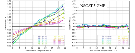
Figure 2 The relative value of sea surface radar backscattering coefficient changing with sea surface temperature under given wind speed
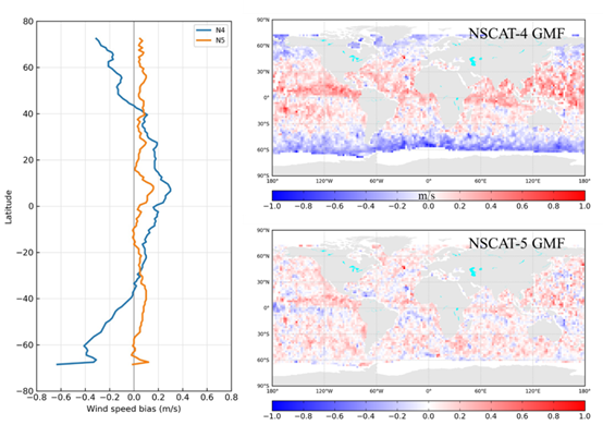
Figure 3 The geographical distribution characteristics of wind velocity deviation retrieval of Chinese HY-2D satellite scatterometer
Reference
Wang Z X, Zou J H, Lin M S, et al. The development
of geophysical model function for HY-2 satellite microwave scatterometer wind
retrievals. National Remote Sensing Bulletin, 2022:1-11 DOI:10.11834/jrs.20222221.
https://www.ygxb.ac.cn/thesis/91/28581853/zh/
